| Gear | dr_Hiddink | Sediment class | dr_Pitcher | Benthis métier | dr_Rijnsdorp | dr_SEAwise |
|---|---|---|---|---|---|---|
| BT | 0.14 | gravel | 0.174 | TBB_CRU | 0.060 | 0.108 |
| BT | 0.14 | mud | 0.181 | TBB_CRU | 0.060 | 0.115 |
| BT | 0.14 | sand | 0.113 | TBB_CRU | 0.060 | 0.047 |
| BT | 0.14 | gravel | 0.174 | TBB_DMF | 0.140 | 0.174 |
| BT | 0.14 | mud | 0.181 | TBB_DMF | 0.140 | 0.181 |
| BT | 0.14 | sand | 0.113 | TBB_DMF | 0.140 | 0.113 |
| BT | 0.14 | gravel | 0.174 | TBB_MOL | 0.140 | 0.174 |
| BT | 0.14 | mud | 0.181 | TBB_MOL | 0.140 | 0.181 |
| BT | 0.14 | sand | 0.113 | TBB_MOL | 0.140 | 0.113 |
| OT | 0.06 | gravel | 0.108 | OT_CRU | 0.107 | 0.193 |
| OT | 0.06 | mud | 0.115 | OT_CRU | 0.107 | 0.205 |
| OT | 0.06 | sand | 0.047 | OT_CRU | 0.107 | 0.084 |
| OT | 0.06 | gravel | 0.108 | OT_DMF | 0.026 | 0.047 |
| OT | 0.06 | mud | 0.115 | OT_DMF | 0.026 | 0.050 |
| OT | 0.06 | sand | 0.047 | OT_DMF | 0.026 | 0.020 |
| OT | 0.06 | gravel | 0.108 | OT_MIX | 0.049 | 0.088 |
| OT | 0.06 | mud | 0.115 | OT_MIX | 0.049 | 0.094 |
| OT | 0.06 | sand | 0.047 | OT_MIX | 0.049 | 0.038 |
| OT | 0.06 | gravel | 0.108 | OT_MIX_CRU | 0.097 | 0.175 |
| OT | 0.06 | mud | 0.115 | OT_MIX_CRU | 0.097 | 0.187 |
| OT | 0.06 | sand | 0.047 | OT_MIX_CRU | 0.097 | 0.076 |
| OT | 0.06 | gravel | 0.108 | OT_MIX_CRU_DMF | 0.076 | 0.137 |
| OT | 0.06 | mud | 0.115 | OT_MIX_CRU_DMF | 0.076 | 0.146 |
| OT | 0.06 | sand | 0.047 | OT_MIX_CRU_DMF | 0.076 | 0.060 |
| OT | 0.06 | gravel | 0.108 | OT_MIX_DMF_BEN | 0.029 | 0.052 |
| OT | 0.06 | mud | 0.115 | OT_MIX_DMF_BEN | 0.029 | 0.055 |
| OT | 0.06 | sand | 0.047 | OT_MIX_DMF_BEN | 0.029 | 0.022 |
| OT | 0.06 | gravel | 0.108 | OT_MIX_DMF_PEL | 0.073 | 0.132 |
| OT | 0.06 | mud | 0.115 | OT_MIX_DMF_PEL | 0.073 | 0.141 |
| OT | 0.06 | sand | 0.047 | OT_MIX_DMF_PEL | 0.073 | 0.057 |
| OT | 0.06 | gravel | 0.108 | OT_SPF | 0.009 | 0.017 |
| OT | 0.06 | mud | 0.115 | OT_SPF | 0.009 | 0.018 |
| OT | 0.06 | sand | 0.047 | OT_SPF | 0.009 | 0.007 |
| OT | 0.06 | gravel | 0.108 | SDN_DMF | 0.009 | 0.017 |
| OT | 0.06 | mud | 0.115 | SDN_DMF | 0.009 | 0.018 |
| OT | 0.06 | sand | 0.047 | SDN_DMF | 0.009 | 0.007 |
| OT | 0.06 | gravel | 0.108 | SSC_DMF | 0.017 | 0.030 |
| OT | 0.06 | mud | 0.115 | SSC_DMF | 0.017 | 0.032 |
| OT | 0.06 | sand | 0.047 | SSC_DMF | 0.017 | 0.013 |
| TD | 0.20 | gravel | 0.254 | DRB_MOL | 0.200 | 0.254 |
| TD | 0.20 | mud | 0.261 | DRB_MOL | 0.200 | 0.261 |
| TD | 0.20 | sand | 0.193 | DRB_MOL | 0.200 | 0.193 |
1.1 Depletion of Benthis métiers
Depletion rates d by sediment class and Benthis métiers
Global depletion rates were first estimated by Hiddink et al. 2017 for four generic gear types (otter trawls, beam trawls, toothed and hydraulic dredges). These estimates were split by substrate type (mud, sand or gravel) by Pitcher et al. 2022 and by Benthis-metier type by Rijnsdorp et al. 2020. The proportional grain size distribution from Mitchell et al (2019) was categorized in three classes (mud, sand and gravel) following Pitcher et al (2022) to estimate sediment-specific depletion rates for each grid cell in the study region.
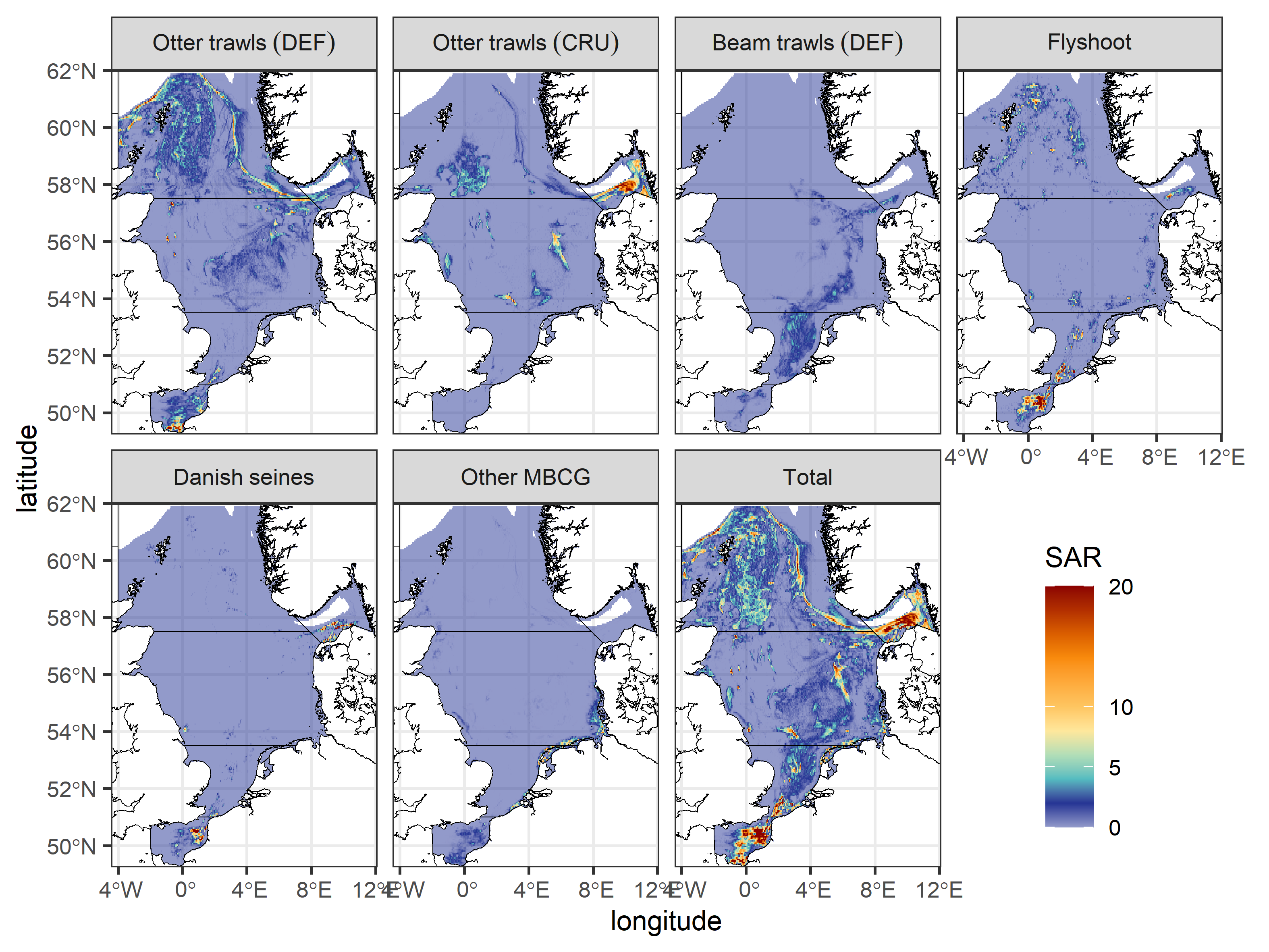
Swept Area Ratio SAR by Benthis métiers
The system’s study area was defined by ICES Divisions 4abc excluding depths below 400 m, as these constitute fisheries regulated by the deep-sea access regulations Van Denderen et al. 2021, and delineated by the availability of longevity data (Rijnsdorp et al. 2018). SAR data were available for 2021 at 0.05 degree resolution for all Benthis métiers formatted in a similar way as the freely available 2009-2020 data from ICES (2021). SAR estimates were pooled into broad categories that could be matched to the fleets and métiers as used in the FLBEIA model. These were otter trawls targeting fish (combining Benthis métiers: OT_DMF,OT_MIX,OT_MIX_DMF_BEN,OT_MIX_DMF_PEL), Nephrops-directed otter trawls (OT_CRU,OT_MIX_CRU_DMF), flatfish beam trawls (TBB_DMF), flyshoot seines (SSC_DMF), Danish seines (SDN_DMF) and other mobile bottom-contacting gears such as shrimp beam trawls (DRB_MOL,OT_SPF,TBB_CRU,TBB_MOL).
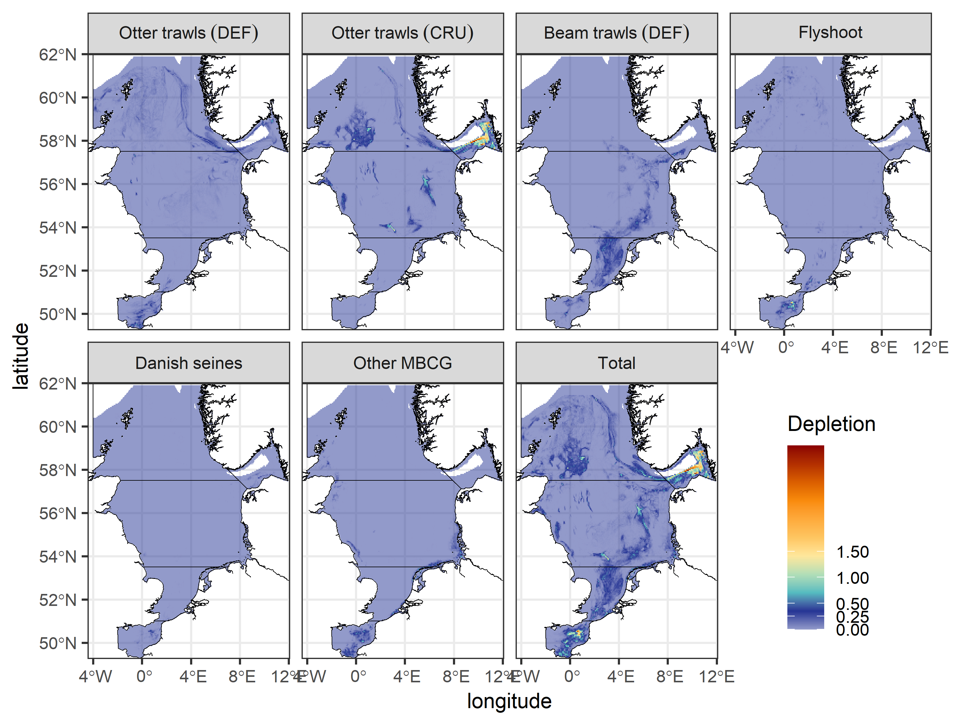
Depletion of pooled Benthis metiers
Swept Area Ratio (SAR) estimates were multiplied with their sediment-specific depletion rates in each grid cell to estimate the depletion caused by the Benthis métiers in 2021.
Code
depl_r <- sar_r_2021[[selmets]] * drate_r[[selmets]] # SAR and depletion rate are multiplied on a grid cell basis using spatRasters